Be passionate, and enthusiastic, in the direction you choose in life... and you'll be a winner! -Steve Irwin

Tuesday, January 18, 2011

Extreme Rafting Trip Planning


For the last 8 years I have organized annual rafting trips down the famous Upper Gauley river in West Virginia. We go during a 22-day period known as Gauley Season. This is when the Army Corp of Engineers have a controlled dam release from Summersville reservoir dam. At the bottom of the dam the mighty Upper Gauley starts it’s decent through some of WV”s most beautiful scenery, while providing some of the best class 5+ white water action the northern hemisphere has ever seen!


There is a lot a variables that go into scheduling this trip, and after so many years of making this run I‘ve figured out a thing or two about planning it. I’ll share some things that may help you with scheduling your trip to have the best time possible.

10,000,000 Acre Forest… Gone


I’d like to share some facts about our precious forest that may shock you. Here is a little history I dug up about the ugly side of deforestation.


Before 1750, over 10,000,000 acres of virgin forest existed in the State of West Virginia. George Washington wrote in his journal while traveling along the Kanawa River, "Just as we came to the hills, we met with a Sycamore of a most extraordinary size, it measuring three feet from the ground, forty-five feet round, lacking two inches; and not fifty yards away from it was another, thirty-one feet round."

Along with massive trees, extensive undergrowth existed as documented by an account written in 1857 by David Strother:
"The hunters had been dodging the laurel-brakes all day. They had stories of men who had spent days in them, wandering in circles, and who had finally perished from starvation. Some of these brakes extend for many miles, and are so dense that even the deer cannot pass except by finding the thinnest places. Ascending the stump of a riven hemlock, a striking picture presented itself.

Monday, January 17, 2011

Get with the Picture


Most families seem to have one person that ends up taking all the photos. Sometimes it’s because you are the best with the camera, and other times it is just because it happens to be one of your favorite hobbies and you just love it. The latter is the case in my family. I will generally be the first one to pick up the camera or video recorder at any opportunity. Because of this, I find that I’m not in the photos as often as I’d like to be. The solution for this is simple, let someone else take some shots or get a tripod. I try and do both.

By letting others take shots it puts a different style in the picture. For example, my 8 yr old son is always

Saturday, January 15, 2011

This Photo is Alive


Some of us may never see the value in snapping photos at every opportunity, but for the ones that do, you’ll be very thankful down the road. For me, it’s about capturing the mood of a particular moment that’s most important. If your family and friends pose for every shot, then they will look very similar in every picture you take.
Next time you turn on that camera try and resist the urge to draw attention to yourself by waving your arms frantically and shouting ’over here!!’, or waiting until it’s all smiles all around, instead take a few shots of whatever is happing right now; without warning. I think you will be pleasantly surprised more often than not. I’m not saying each photo will be great, but they will all catch

Wednesday, January 12, 2011

Humpback Rocks

On the Blue Ridge pkwy, at milepost 6, there is a great little spot called Humpback Rocks. There is parking on either side of the parkway here - visitor’s center and old pioneer village is on the west side and trailhead parking for the Humpback Rocks trail is on the east side.

This was part 2 of the Adventure Club’s November 2010 trip “Birds of Prey / Bird’s Eye View”. The first part of the day had been spent touring The Wildlife Center of Virginia, and as neat as that was, it was time to get some hiking in! Humpback Rocks is an outcropping of granite high in the mountains. The trail is only about 8 tenths of a mile long but the elevation gain is over 1000 feet! That’s steep people. Never-the-less, we all made it to the top just fine. The ages on our hike ranged from 8 - 45 yrs old. The view from the rocks was amazing to say the least. I spent a lot of time searching for the best photo spots up there and took lots of shots with the kids. My favorite photo of the trip was this shot of the Adventure Club boys hanging out on the rocks. This picture is somewhat deceiving though, they’re actually laying down on the rocks on about a 45 degree angle so I just angled the camera to create the cliff scene.

After spending 2 hours at the top, just hanging out with great family and friends, we started our decent. Going down this trail proved to be very rough on the knees, but nothing a long drive back home wouldn’t cure.

Birds of prey

In November of 2010 the Adventure Club and I traveled to the mountains for the trip we called, Birds of Prey / Birds Eye View. The plan was to visit the Wildlife Center of Virginia, where we would take a tour of the facilities and get to know some of the birds of prey that they were helping at the time.

The Wildlife Center is located near Waynesboro, Virginia and right off of interstate 64. It was very easy to find. I had called ahead to schedule our tour, but I’m sure they wouldn’t mind a stray visitor from time to time. There was a fee involved for the tour, however, most of the fee went directly to the treatment and care of our native Virginia wildlife so we did not mind at all. First we watched a short video about the Center and the animals they cared for, and afterwards our guide held a general Q&A session. The kids took full advantage of asking some very unique, and down right weird, questions and I think I even saw our poor tour guide blush once or twice. Once we were all educated in the Center’s daily operations we ventured out back to where the birds of prey were housed. The enclosures were kept very tidy and the birds looked very well taken care of, despite their injuries. We learned even more about the Owls, Hawks, Eagles, etc., then it was time to say good-bye. The tour was about two hours in length.

I would recommend visiting The Wildlife Center of Virginia to anyone who may be interested in a career of helping native wildlife, the staff was very helpful and very eager to educate us.

The second part of our day we would spend hiking a nearby trail at Humpback Rocks.

Tuesday, January 11, 2011

Learn S.T.O.P.


In the wild, most people don’t realize that they are in fact lost until they have been truly lost for quite some time. You don’t just cut a corner and say…huh!? I’m lost. It usually starts with you quietly doubting yourself, then it turns to you trying to re-assure yourself that salvation must be just over there, or maybe just over here. As your immediate conditions dwindle you are suddenly faced with a choice, a choice you will not have complete control over; to panic or keep your wits.

I think most people automatically panic, even if it’s just

Lost in the wild


The old saying is; “When you’re lost in the wild, your best bet is to find water, follow it downstream until it becomes a creek, then a river, and your sure to find civilization”. This is great advice, unless you’re lost in the upper regions of Canada, with more fresh water streams, rivers, and lakes than you can poke a stick at. What if you follow a stream, and after hours of winding back and forth along its banks, you find yourself at the shore of a remote lake? I would say, that finding water should be a top priority, but you might not always find the salvation you’re looking for

Monday, January 10, 2011

Niagara Falls in winter

Niagara Falls in January is quite a site. Ice formations cover the sides of the cliffs around the falls from the never-ending spray. The mist from the falls fall back to the ground as ice pellets and cover the surrounding area under a heavy coat of ice. None-the-less, it was our first trip to Niagara Falls and we were loving it!

 This photo here is actually the American Falls, we would later venture out to Goat Island and also get a view from the top of Niagara. Because it was winter, all other vantage points were off limits and the boats below were dry docked because of the ice.

Drive to Lake Erie

A few years ago, we were having an abnormally warm winter here in Virginia. Only an inch or two of snow had fallen and it was already fast approaching the end of January. Well, we decided that just would not do. So we did what any snow loving family would do… we went to snow!

We called it our annual “family snow day”. The idea was inspired by something my friends and I used to do when we were younger (and gas cost less than a dollar a gallon). We would watch eagerly as the forecasters called for snowfall in our area, only to have the mountains suck out all the moisture and deny us of any snow at all. This happened over and over until one day we got the bright idea that we would simply go to the snow. This sounded great, after all, how nice it is to leave home on a Friday afternoon and be in a hotel deep in the mountains by late evening with three to four feet of snow outside on the ground. Play all day on Saturday in the snow, then drive Saturday night with clear road conditions back home. You still had a day to recoup and then back to work, awesome right? My thoughts where, wouldn’t this same plan work with my family?

Sure it would. Times had changed though, back then we’d just get in the car, and then come up with a plan. No way, not today. I had to come up with a decent plan of action before we even left the house this time. So I researched what parts of the U.S. had the most snowfall on average that was within a one day journey by car. There were two places that I found, the first was Elkins, West Virginia - which I had done when I was younger with my friends and found as much as 4 feet of snow back then!- the second place was Jamestown, New York (which is about 60 miles south of Buffalo) and was claiming to have 3 feet of snow on the ground now with more on the way! With all the lake effect snow pouring down at Jamestown, NY I new this was our destination.

The plan was to make it a three-day weekend since we had about 9 hours each way of drive time. We left home at 4am on Saturday to arrive at a hotel around 1pm that afternoon. The temperature was about 45 degrees as we left our house in Virginia, in the early hours of the morning, still much warmer than average for late January. About 6 hours later we stopped for fuel in Pennsylvania and “man alive!!” was it ever cold. We past a bank sign a few miles later and I believe it read 16! I know some of you may think that’s not quite ‘arctic cold’ but for it being in the mid-40’s earlier that day, we noticed.

As we drove closer to Lake Erie a snow storm developed out of nowhere, then the wind picked up, before we knew it we where in white-out conditions and a full blown blizzard was on us! Then, just as quickly as it came on, it lightened up and started to clear. That only lasted about 10 miles, but traffic had slowed to a crawl and it was quite exciting. We actually decided to stay at a hotel right on the shore of Lake Erie (20 miles west of Jamestown). The lake was froze over as far as the eye could see, which made for a pretty cool view out of a second story window. There were people out on the ice in little huts, it took me a minute to figure out that they were ice fishing. “How cool is that!”, I told my kids. We had never seen anyone doing this before except on TV.

Once at the hotel room, we decided that we wouldn’t waste a single minute. We through our stuff in the room and jumped right back in the car. Now… where to? Well we as close as we had ever been to Niagara Falls, so that was it, to the FALLS!

900ft Zipline

Tales of a 900 foot zipline buzzed around the web, and right here in our own backyard.


In May of 2010 The Adventure Club of central VA set out to conquer the zip line at Eagle Landing in our own beautiful Blueridge Mountains. We were all a little nervous and some more than others I believe. Non-the-less, there we were staring down a 900 foot long cable that ended abruptly at a tower… and over a lake!

No turnin’ back now…

Never too late to start

If it’s adventure you seek, then I know how you feel. I spend countless hours researching locations, scouting, and talking to all the right people just to be able to plan out the most enjoyable trip a group could ever have. I do this simply because I love it! My reward comes from the satisfaction of others, especially my family. There is no better legacy than one made up of great memories! Already I know my kids will look back with great joy on the adventures we’ve been through together, and we’re just getting started. If anyone were to ever ask me for advice on fatherhood, I’d simply tell them just be there, be active, and be patient and strong. It’s never too late to start, now get out there and have some fun, make some memories together today.

Skyline Hike


Everyone has a different view when it comes to adventure it seems. For some it takes skydiving over a volcano to qualify as an adventure, for others, just doing something different qualifies.


Recently I took my kids to Skyline Drive, VA, but when we arrived at the entrance the sign read "CLOSED DUE TO ICY ROADS". This possibility should have crossed my mind beforehand, after all, it was December 22nd and there had been a snow storm only a week before. This may seem like a missed opportunity, and a waste of a drive, but then another thought came to me. We parked at the closed visitor's center and decided to walk a couple of miles of this ‘out-of-order’ road, then return. With the camera and plenty of water in hand, we found an excellent 24 foot wide hiking path with endless vistas and even some cool ice formations draping from the rocky cliffs along the road. At the end of the day we had a very unique experience that we would not have otherwise done had the road been open.

Details of our hike - We started out on route 211, heading west from Sperrysville, VA towards Skyline Drive. When we reached the top where Skyline Dr. intersects with Rt.211, we parked at the visitor’s center. The center was closed except for the bathrooms which were still open, and luckily heated too. The area is called ‘Panorama’, at least that is what the sign said just beside us on the road. The kids and I set out heading south on Skyline and walked to the tunnel, a couple of miles away. I got some cool shots of the kids playing with the icicles and trying to skate across frozen puddles on the road. It was a little windy, and the temps were in the 30’s, so we only hiked for a couple of hours. In the end we all had a great time, and experienced something new… together.

Sunday, January 9, 2011

Author's Quest

“I believe the best way to win your children’s admiration is to simply do things with them, often. It doesn’t even matter how you do it, just spending time together is all that’s really important. Now take that and add in some adventure, well… now we’re on to something special!”

It is more important than ever that we give our kids as much knowledge as possible before they go out and face this unpredictable world. Times have changed dramatically since our parents let us roam from dawn ‘til dusk, and if we want our kids to listen to what we need to say, then we’re going to have to get creative.

I’ll admit it, I didn’t do a very good job at listening to my parents when I was young. In fact, all I wanted to do was have fun and it seemed to me that all my parents wanted was for me NOT to have fun. It was just that simple when I was a kid. Of course I know better now, but if my mom and dad would have taken me on various adventures all the time, and had those important talks with me while we were on an awesome adventure then I would have probably listened a lot better. At least, that’s my theory. It’s a theory I am putting to the test right now with my own children!

My name is Doug Robinson, author of this Blog, and I’d like very much to share with you my journey through the Family Adventure Zone. I have many passions in life, the biggest by far are my three children. I would do anything for my family, just like most of you. I don’t dare sit here now and tell you that my way of parenting is in any way superior to any of yours, I’m just sharing my ways in hopes that any success I may find can be utilized by all of you.

I’m sure there are actually many ways to achieve a close family bond, this is just my way of doing it using the tools at my disposal. So please, enjoy reading all about our family adventures, and outings, and lessons we learn along the way. Thank you!

Doug Robinson

Mt Rogers Expedition


In June of 2010 fourteen people, and one loyal dog, set out to hike the tallest piece of ground in the state of Virginia – Mt. Rogers.

Our expedition was a planned three day outing from leaving home Friday morning to returning home on Sunday afternoon. It took about five hours of driving to get to our campsite. We camped at the Grayson Highlands State Park campground, very near trail access for Mt. Rogers. The sites we choose after getting there were great, nice and quiet, plenty of trees, just the way a campsite should be in my opinion. A very family friendly atmosphere was what we were seeking, and that’s just what we found. Camp life is never boring. We quickly set up tents and started unpacking stoves, lanterns, and chairs, and all the other camp accessories one could possible ever need on a two night camping trip. The shadows were getting long, and the smell of campfires was in the air. We ate our dinner and told stories of our lives while the kids played, with what seemed like an unlimited supply of energy and enthusiasm. By-the-way, earlier when I mentioned that the campground was nice and quiet… that was before we arrived! With anticipation of our twelve mile round trip hike the next day we were off to bed.
Side note: If you are going to sleep in a pop-up make sure all of the foot pads are down before everyone piles in and moves to one end of it… although if you want a good laugh, don’t!

Early morning at camp has always been one of my very favorite times of day. I try to be the first up, usually beating the sun, bringing the fire back to life and enjoying nature quietly and all alone. This generally doesn’t last too long as the mob of hungry and sleep deprived campers emerge from their tents and “rockin pop-ups”. After a good breakfast we wasted no time prepping for our hike up the mountain. We packed lunches and snacks, along with as much water as we could carry for our journey.
 
We only lost our way once throughout the entire trip, and believe it or not, it was the short one mile drive to the trail head that got us. Okay, I’ll admit it… when I say us I mean ME! I was driving the lead vehicle and simply turned left out of the main entrance of the park when I should have turned right. Easy mistake right? Anyway, we found the trail and parked our vehicles. The first thing that caught us off guard was the WIND! I bet there were 30-40 mph wind gust at the trail head as we started out, and it made that mountain morning air feel down-right chilly - even for the middle of June.

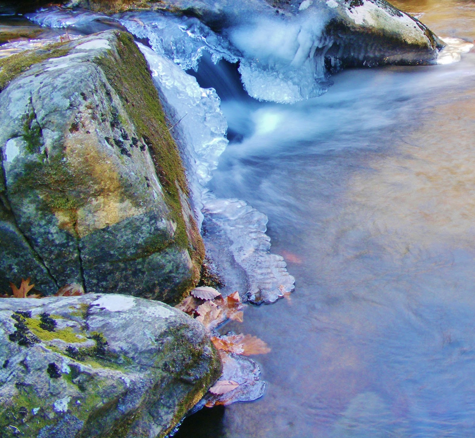
We decided to take a short side loop trail right from the start, since we felt that if we didn’t do it now – no one would want to after hiking to the peak of Mt. Rogers, and we were right! The side loop was called the Cabin Creek trail and it led to an awesome waterfall and great photo op for our group. CC trail was only about a mile in length and made for a great warm-up hike for us, and it got us out of that wind for a bit. I would highly recommend this short loop to anyone visiting the area.

Once we were “warmed up”, it was back to the wind swept balds that cover a great deal of the mountains leading up to Mt. Rogers. We gained elevation fairly quickly over the first few miles, but the trails were pretty gentle under foot. The views were totally amazing walking up the trail, you really felt like you were hiking to the top of the world. Next up, Wilburn ridge!

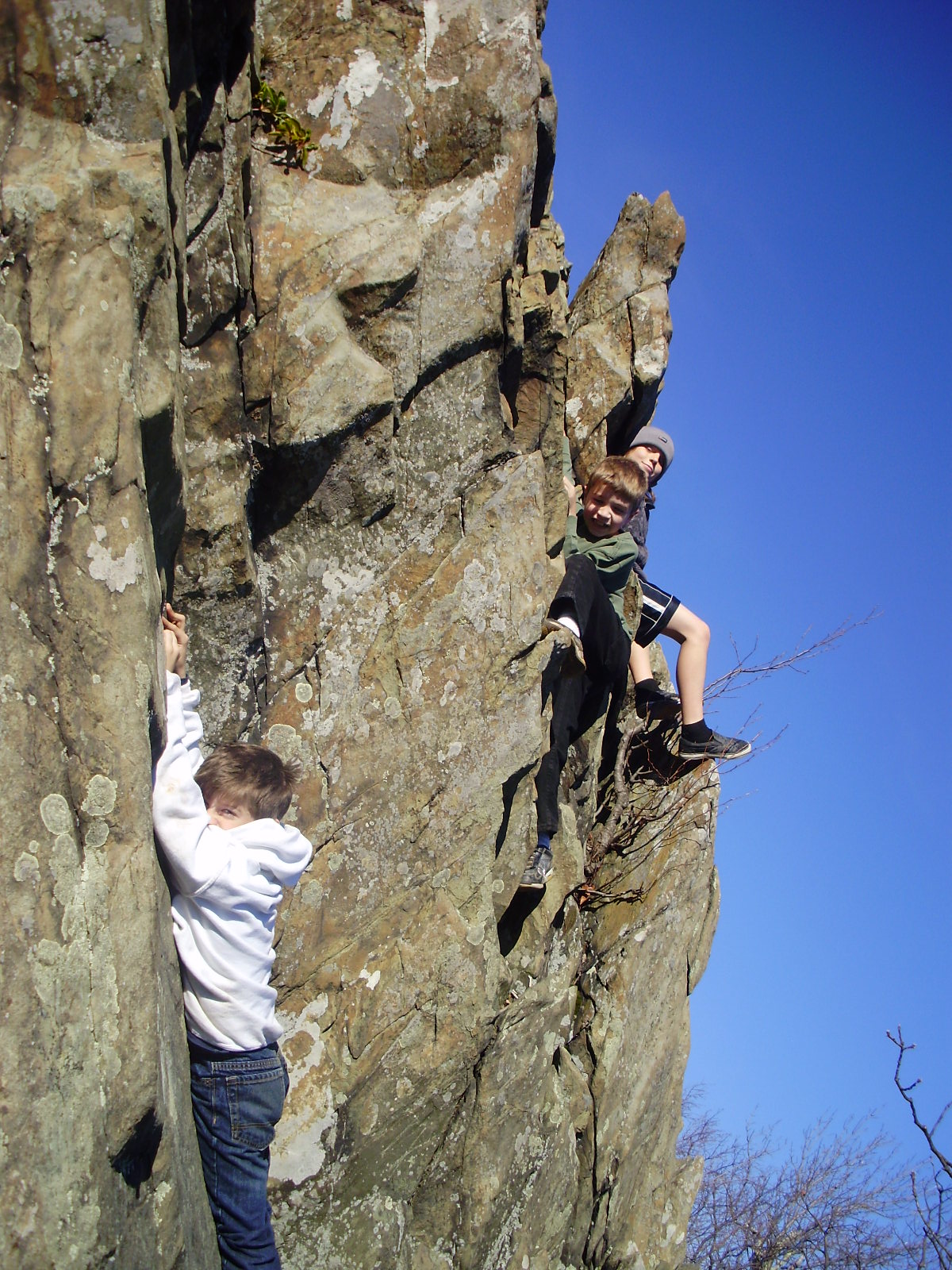
 As you’re hiking up the trail towards the ridge, you can see it in the distance for a while. We’d look up and say “Wow, check out that outcropping of rocks over there, bet the views from up there would be great!” You start to get closer and closer until you realize that the trail that’s under your feet will take you right over the top and along the ridgeline, cool! By this time on our journey that gentle trail is starting to get rocky at times, sometimes we would find ourselves just hopping from boulder to boulder without touching dirt for long stretches at a time.

After enjoying 60 mph wind on the peak of Wilburn, we decided to continue onward and upward. For the time being we were enjoying the lack of elevation changes, and the soft grasses that the ridgeline offered. Somewhere along here we stopped for lunch, but I really don’t remember exactly where. We ate without hesitation though, our bodies craved carbs!


Grayson Highland ponies were something I’d hoped we’d see along the way, although I figured we would spot them nervously grazing in a distant field along the way. Oh no! They stood right on the trail as if someone told them that we were coming and they had decided to welcome us. “What a magical experience for our kids!” That’s what I remember thinking as I stood and watched my ten-year-old daughter, who loves horses very much, run her fingers through the wild ponies’ mane with a smile so big, it was impossible to hide. We spent some time here, after all, when might this opportunity happen again?

Eventually we said good-bye to our new friends and moved on up the trail. The hike now resembled a walk through gentle rolling hills, on a summer afternoon (because it was). The wind had died down a lot, and the sun was high in the sky. Our water supply was running really low by now, and our next stop was Thomas Knob Shelter, where we would take advantage of a natural spring and refill our water bottles. Most of us waited at the shelter while a few of us hiked, a hundred or so yards, down the hill to the spring. The spring location was well marked and easy to follow. We used a filter pump system to fill our water containers, I would not recommend drinking straight from any water source in the wild, more on that later. I haven’t spoke much about the views lately, but they don’t seem to stop. All day long there was a “wall worthy” picture hanging just over our shoulders as we made this hike.

Just after leaving Thomas Knob shelter, and then briefly exploring the famous facilities that it offers (being extremely sarcastic!), we came to the spur trail that would take us up to the peak of Mt. Rogers. Unfortunately, this spur trail offers no great views. What is does offer though is a very unique forest hike. The Spruce-Fir forest on Mt. Rogers is quite different than any other terrain that we had covered to this point on our hike. The forest, even on a sunny day, is dark and moss covered. Needles from the evergreens cover the ground every where making it impossible for undergrowth. What a great example of a boreal forest right here in Virginia.

Summit! At 5729 feet above sea level, Mt Rogers is the tallest peak in Virginia. We had a great time exploring all over the peak, although it’s much the same, moss covered rocks and Spruce trees every where you look. We located the U.S.G.S. plate and pinpointed the absolute highest point. We all stood on top for a moment and crossed off yet another great challenge from our list! Next… the hike back down.

Mini-WaterFalls

One of the neat things about hiking trails with no names is you never know what you might find.
On a trip to Skyline Drive one day I noticed a small trailhead just off the road near the entrance to Shenandoah Forest. I decided that I would hike up the trail for a few miles to see what it had to offer. Now, I won't butter it all up for ya, there didn't seem to be a whole lot that this trail had to offer, other than plenty of solitude. None-the-less, I'm not one to miss the opportunity to snap a few shots of any waterfalls along the way. It was winter, and bitterly cold that day I might add, so the mini-falls looked pretty neat with the ice formations all around them. I'll try and find out the name of the creek so that if any one else would like a nice easy hike with tons of solitude, and a seemingly unending path to nowhere, can also enjoy it.

Paintball Wars


A short drive east on I64 from Richmond will take you to one of the best hidden paintball facilities around. New Kent Paintball Games, in New Kent county, has quietly been there for many years offering ten acres of fields, trenches, bunkers, and towers to challenge you, no matter what skill level you are. Within each field you may play different scenarios or objectives and each game is set with it‘s own time limit as well. Field sergeants will help you lead the charge in military style tactics in order to complete your teams objective.
NKPG offers rental equipment too, if you don’t have your own already, making it possible for anyone to come out and play without having to invest a small fortune in equipment. Many players do spend small fortunes on equipment however, and if that sounds like you, then certainly you will find yourself in good company here. There is an equipment shack on site offering supplies and great gear talk with the knowledgeable staffers.
Just to add to the theme of the day, lunch transport is provided for any who wish to ride along on the Deuce-and-a-half military transport vehicle. Quite the ride, and an experience all by itself.
Year round play is available to “walk-ons” on the first and third Saturday of each month. NKPG is a real easy going place, however, they’re also very professional when it comes to safety and fair play. Your field fee is a full day pass, and you get a lot of value for the money. Field judges help to keep order and make unbiased calls throughout the day, and there’s never any shortage of experience out on the field.
For more information about New Kent Paintball Games, including prices and events, check out http://www.newkentpaintballgames.com/index.html
 

Old Rag Mt. 2010

 Our trip to Old Rag mountain in March 2010.

After arriving late, just about noon I think, we set out to hike Virginia's most popular hike - Old Rag.

Old Rag Mountain is located in Shenandoah National Forest in the Blue Ridge mountains of Virginia. With an elevation of 3291 feet it offers up some spectacular views for much of this hike.
However, it's the boulder scramble that make this hike VA's most popular.

Trail note: We arrived at noon on a Saturday in March and the weather was very nice... which meant "themepark like" lines to get through some of the more challenging spots on the mountain and absolutely no solitude on this hike. This is a must do hike, but I would suggest early morning at the trailhead to beat the crowds. If you think it's a nice day for a hike, then so does everyone else!